Basic Facts on Nagaland State:
- Location: Nagaland is a state in India.
- Capital of Nagaland: Kohima
- Area: Nagaland is 16,579 square kilometers in size. (0.50% of area of India)
- Nagaland state formation: 1st December 1963
- Nagaland is the 16th state of India
- Official Language of Nagaland: English
- Type of Legislative Assembly: Unicameral
- No. of Assembly Constituencies seats: 60
- No. of Parliamentary Constituency (Lok Sabha): 1
- No. of Parliamentary Constituency (Rajya Sabha): 1
- Festivals: Nagaland is known as the “land of festivals” and celebrates many tribal festivals. The Hornbill Festival is one of the most vibrant festivals.
- Music and dance: Music and dance are an important part of Naga culture. Each tribe has its own traditional songs and dances.
- Crafts: Nagaland is famous for its traditional textiles, woodcarvings, bamboo and cane products, and handmade pottery.
Nagaland State Symbols:
- State Animal of Nagaland 🐄: Mithun (Bos frontalis)
- State Bird of Nagaland 🐦: Blyth’s tragopan (Tragopan blythii)
- State Flower of Nagaland 🌸: Rhododendron
- State Tree of Nagaland 🌳: Alder (Alnus nepalensis)
- State Fish of Nagaland🐟: Chocolate Mahseer ( Neolissochilus hexagonolepis)

Scientific Name: Bos frontalis

Scientific Name: Tragopan blythii

Scientific Name: Rhododendron arboreum

Scientific Name: Alnus nepalensis

Scientific Name: Neolissochilus hexagonolepis
Nagaland Geography
- Total Area of Nagaland : 16,579 sq. km (6,401 sq mi)
- Nagaland lies between Latitude: 25o 6’N to 27o4’N and Longitude: 93o 20’ E to 95o15’E
- Area rank: 26th in India (0.05% of geographical area of India)
- Nagaland State shares boundaries with the following Indian states-
- East – Myanmar & Arunachal Pradesh
- West – Assam
- North – Assam & Arunachal Pradesh
- South – Manipur.
- Nagaland shares the international border with Myanmar (Burma).
(Longest boundary shared by Nagaland with another state is: Assam)
- Largest City in Nagaland: Dimapur
- Largest District in Nagaland by Area: Tuensang*
(subject to change after several districts have been carved out of Tuensang) - Smallest District in Nagaland by Area: Longleng
- Eastern-most District of Nagaland: Tuensang
- Biggest Village in Nagaland: Kohima Village (considered to be the second largest village in Asia)
- Biggest Lake in Nagaland: Shilloi Lake
Nagaland Population (as per 2011 Census)
- Total Population of Nagaland: 19,78,502
- Male : 10,24,649 | Female : 9,53,853
- Sex Ratio (no. of females per 1000 males) : 931
- Percentage of Rural Population : 71.14 | Percentage of Urban Population: 28.86
- Density of Population (per sq. km) : 119
- Human Development Index (HDI): 0.770 (high)
Population of Nagaland in 1901: 1,01,550
(Ref: Statistical Handbook of Nagaland 2021)
Nagaland Literacy Rate (as per 2011 Census)
- Literacy Rate of Nagaland : 79.55 %
- Male : 82.75 % | Female : 76.11 %
Administrative Units
- Districts : 16 (as of Jan.2022)
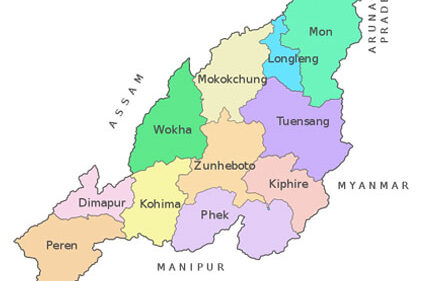
- Names of Districts of Nagaland:
(1) Kohima (2) Mokokchung (3) Tuensang (4) Mon (5) Wokha (6) Zunheboto (7) Phek (8) Dimapur (9) Peren (10) Longleng (11) Kiphire (12) Noklak (13) Tseminyu, (14) Niuland, (15) Chümoukedima, (16) Shamator
(Refer to ‘Formation of Nagaland State and its districts‘ and ‘Districts of Nagaland‘ for more details)
- Circles (ADCs, SDOs, EACs) (as per 2011 Census): 133
- Statutory Towns (as per 2011 Census) : 19
- Census Towns (as per 2011 Census): 7
- Police Stations (2012): 61
(As of 2023, there are 84police stations in Nagaland. Also See: List of police stations in Nagaland)
Naga Tribes in Nagaland:
17 recognized tribes of Nagaland (in Alphabetical Order)
(1) Angami,(2) Ao,(3) Chakhesang,(4) Chang, (5) Kachari,(6) Khiamniungan,(7) Konyak, (8)Kuki, (9) Lotha, (10) Phom, (11) Pochury,(12) Rengma,(13) Sangtam, (14) Sumi, (15) Yimchunger, (16) Zeliang, (17)Tikhir
Backward Tribes of Nagaland
The following nine (9) Naga Tribes are considered ‘backward tribes’ for the purpose of reservation by Govt. of Nagaland.
(1) Chakhesang, (2) Chang, (3) Khiamniungan, (4) Konyak, (5) Phom, (6) Pochury, (7) Sangtam, (8) Yimchunger and (9) Zeliang.
Besides the above, ‘Sumis’ from Kiphire District are also entitled reservations under backward category.
Scheduled Tribes recognized by the Government of Nagaland:
1. Naga, 2. Kuki, 3. Kachari, 4. Mikir, 5. Garo
Ref: Dept. Personnel and Administrative Reforms , nagaland.gov.in
Eastern Nagaland
- Eastern Nagaland comprises six districts – Tuensang, Mon, Longleng, Kiphire, Noklak and Shamator
- Inhabited by seven Naga tribes: Konyak, Khiamniungan, Chang, Sangtam, Tikhir, Phom and Yimkhiung
Protected Areas in Nagaland
• Intangki National Park, Peren district, Area: 202.02 Sq. Kms.
• Rangapahar Wildlife Sanctuary, Dimapur district , Area: 4.70 Sq. Kms.
• Fakim Wildlife Sanctuary, Tuensang district , Area: 6.42 Sq. Kms.
• Puliebadze Wildlife Sanctuary, Kohima district , Area: 9.23 Sq. Kms.
Nagaland Physiography
- Highest Peak in Nagaland 🗻: Mount Saramati, Kiphire (3840 meters)
- Second Highest Peak in Nagaland🗻: Japfü Peak (3048 mtrs)
- The major rivers in Nagaland include the Dhansiri, Doyang, Dikhu, Tizu, and Lanye
- Biggest river in Nagaland: Doyang, Wokha
- Biggest Lake in Nagaland: Shilloi Lake, Phek
- Soil Types in Nagaland: ferrugineous red soils and laterites
- Seismic Zone: Zone V (Very High Damage Risk Zone) of the seismic zoning map of India
Nagaland Climate
- Nagaland enjoys a pleasant and moderate climate throughout the year.
- Climate in Nagaland is classified as Sub-Alpine climate / salubrious climate.
- Annual rainfall averages around 70–100 inches (1,800–2,500 mm), concentrated in the months of May to September.
- Temperatures range from 21 °C (70 °F) to 40 °C (104 °F )
- Wind: Strong Northwest winds generally during February and March.
- Average Rainfall in Nagaland: 2500mm
Nagaland Flora and fauna
Dominant flora:
Mahogany, Palms, Rattan, Bamboo, Pinus Khasyia, Pinus Caribiae, Rubia cordifolia, Passiflora edulis, Oroxylum indicum, Elaeocarpus ganitrus, Dipterocarpous macrocarpous, Shorea assamica, Mesua ferra, Panax gensing, Aquilaria agallocha, Pleoni, Phauis, Cymbidium tigrinum etc.
Dominant fauna:
Mammals – Tiger, Elephant, Wild Dog, Mithun, Hoolock Gibbon, Goral, Barking Deer, Kallej, Sloth Bear, Flying Squirrel, Buffaloes, Sloth bears, Palm civets, Leopards, Pangolins, Porcupine, Sambar, Elephants etc.
Forest types of Nagaland:
- Northern Tropical Wet Evergreen Forests (found in parts of Mon District)
- Northern Tropical Semi Evergreen Forests (found in foothills of Assam-Nagaland border in Mokokchung, Wokha and Kohima Districts)
- Northern Sub-tropical Broad Leaved Wet Hill Forests (found in hill areas below 1800 m and above 500 m)
- Northern Sub-tropical Pine Forests (found in hill elevation of 1000 meters to 1500 meters in parts of Phek and Tuensang Districts of Nagaland
- Northern Montane Wet- temperate Forests (found on the higher reaches of the tallest mountains in Nagaland above 2000 meters in – Japfu, Saramati, Satoi, Chentang ranges.)
- Temperate Forests (found in peaks of the tallest mountains (above 2500 meters) like Saramati and Dzukou area)
(More details on forests types of Nagaland here)
Rivers of Nagaland
- The major rivers of Nagaland are: Doyang, Dhansiri, Dikhu, Milak, Zungki and Tizu.
- Biggest / Longest river “in Nagaland”: Doyang, Wokha
- Rivers which drains into Brahmaputra: Doyang, Dikhu, Dhansiri flows westward and drains into Brahmaputra.
- Rivers which drains into Chindwin river in Burma: Tizu river flows eastwards and drains into Chindwin river in Burma.
Mineral Resources found in Nagaland
- Nagaland has rich mineral resources, including coal, limestone, iron, nickel, cobalt, chromium, magnetite, copper, zinc, platinum, petroleum and natural gas.
- The State has huge caches of unutilized and unexploited limestone, marble, granite, petroleum and natural gas.
Also See:
- History of formation of Nagaland and its districts
- Tribes of Nagaland and respective districts
- National Parks and Wildlife Sanctuaries in Nagaland
- Rivers of Nagaland
- Districts of Nagaland
- State Symbols of Nagaland